You’re far away, but you still need visibility. What you see from space helps, but you need details and verification.
Now, you can combine the dynamic satellite imagery from Planet with crowdsourced ground truth observational data from Premise, getting you closer to actually being there than ever before.
Premise has partnered with Planet Federal to combine dynamic satellite imagery with crowdsourced observational data. Together, the two companies provide enhanced situational awareness by monitoring and validating global events at the speed they develop. These capabilities enable GEOINT analysts to identify and act on activity-based signals, previously difficult to discern.
When Planet’s machine learning-based imagery analytics identifies activity-based signals, Premise can task people on the ground with taking photos, videos, and surveys to better understand what’s really happening then and there.
Use Case: Understanding Changes in Infrastructure
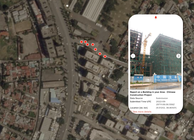
Planet and Premise recently collaborated to observe a China Communications Construction Company (CCCC) construction project in Addis Ababa, Ethiopia. By layering Premise’s on-the-ground observations with Planet’s high cadence satellite imagery collection, analysts were able to track several events along Ring Road, a well-established area of Chinese investment over the last decade. The data helped produce key insights around site change-detection, presence of foreign workers and equipment, and opinions of the local population on foreign investment.
Planet captured imagery of new construction using change detection algorithms. Using Planetscope, it conducted daily monitoring using high-frequency global coverage, rapid high-resolution tasking, automated feature extraction and classification, and easy access and integration. This allowed Premise to analyze the high-resolution satellite images and work with Planet to produce a 3D Digital Surface Model and identify building heights.

Premise + Planet Partnership
Premise has a network of over six million global smartphone users capturing data in realtime and giving our clients visibility in over 140 countries. Premise enables quick analysis and has a proven track record across several industries. Past use cases have included monitoring construction, understanding supply chain activity, and tracking economic development.
Through our partnership with Planet, our customers can monitor and respond to global changes by using our combination of ground observations and infrastructure satellite images. Our partnership will enhance global operations and decision making, increase the speed and scale of analytical processes, and offer clarity about locations around the globe that have previously lacked data. Our combined capabilities allow decision makers to effectively monitor, evaluate, and interpret complex and difficult to reach areas. Our new partnership with Planet Labs will connect both global and local contexts and expand situational awareness.
To learn more about Premise’s partnership with Planet Federal, check out our joint whitepaper.

